Badain Jaran
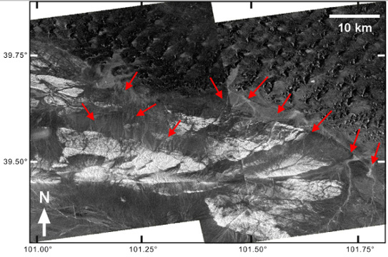
Radar images of the southern Badain Jaran desert: the intermittent
stream channels, originating from the southern mountains, appear
as bright linear forms on the radar images (red arrows).
The images
are from the ALOS/PALSAR instrument (source JAXA).
We studied the dune formation in the Badain Jaran desert in western China, where Earth's tallest dunes occur. We measured the variability of the dune morphology on the basis of LANDSAT ETM+ data, and we detected the bedrock landforms beneath the aeolian sands by applying gravity methods.
Orbital radar images from the PALSAR sensor and SRTM topography were also examined to augment our interpretation. Our study demonstrates that, in addition to average wind parameters, dune height is highly sensitive to local geology, subsurface characteristics and topography, interactions between changing climate conditions and aeolian and fluvial processes.
X. Yang, L. Scuderi, T. Liu, Ph. Paillou, H. Li, J. Dong, B. Zhu, W. Jiang, A. Jochems, G. Weissmann, "Formation of the highest sand dunes on Earth", Geomorphology, vol. 135, pp. 108-116, 2011.