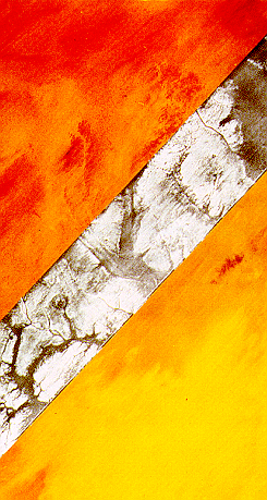
First L-Band SAR image over Sudan desert showing the subsurface bedrok covered by sand (NASA/JPL, SIR-A mission, 1981)
Radar Basics
As was demonstrated by the Shuttle Imaging Radar (SIR) missions in the early eighties, radar signals can penetrate the superficial sand layer and reveal unknown paleo-hydrological and tectonic structures. Low frequency SAR allow a unique access to subsurface information down to a depth of several meters in arid areas: previous studies have shown that L-band (1.25 GHz) SAR is able to penetrate meters of low electrical loss material such as aeolian sand. In particular, SIR-A L-band radar revealed in 1982 buried and previously unknown paleo-drainage channels in south western Egypt, which afterwards were confirmed during field expeditions.
During the 90s, SIR-C data were used to map subsurface basement structures that control the Nile's course in north-eastern Sudan: numerous hidden faults were detected, thus helping to better understand the Cenozoic uplift of the Nubian Swell. More recent studies have shown that combining SRTM – Shuttle Radar Topography Mission – topographic data with SAR images better reveals subsurface features which still present a topographic signature.
New paleo-drainage flow directions have been mapped in the eastern Sahara, allowing better definition of drainage lines leading to oases and valleys. In particular, the Japanese PALSAR sensor recently revealed a 1300-km long paleo-river in eastern Libya, that was connecting the Kufrah oasis to the Sirt Gulf in the past.