Arkenu Craters
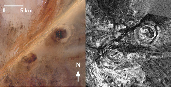
LANDSAT 7 ETM+ image of the Arkenu double impact crater (left) and corresponding JERS-1 radar image (right) at resolution of 50m.
Using L-band SAR images acquired by the japanese satellite JERS-1 in 1992, we discovered a double impact crater in southern Libya. The structure is located 110 km west of Djebel Arkenu and 250 km south of Kufrah oasis in Libya, at coordinates 22o04’N, 23o45’E. It is a flat and hyper-arid area covered by active aeolian deposits.
The optical Landsat 7 ETM image of the region (left) shows a sandy region with large sand dunes trending SW-NE, while the corresponding L-band SAR image acquired by JERS-1 (right) reveals two circular structures partially hidden by Quaternary deposits. The NE crater, 6.8 km in diameter, is composed of concentric inner and outer rings separated by a depression filled with sediments. Its morphology is very similar to the Aorounga crater in Chad, corresponding to a typical complex crater.
Shatter cones and breccia were observed during field work in April 2003. Planar fractures were also found into rock samples, confirming the impact origin of the craters.
Ph. Paillou, A. Rosenqvist, J.-M. Malézieux, B. Reynard, T. Farr, E. Heggy, "Discovery of a double impact crater in Libya: the astrobleme of Arkenu", C.R. Geoscience, vol. 335, pp. 1059-1069, 2003.