Kufrah River
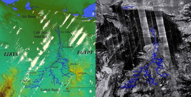
The Kufrah River (in blue) mapped onto SRTM topography (left) and
PALSAR
mosaic (right).
The red dotted line represents a possible path to the Mediterranean
coast.
Using orbital radar satellite imagery, we mapped a major paleodrainage system in eastern Libya, that could have linked the Kufrah Basin to the Mediterranean coast through the Sirt Basin, possibly as far back as the middle Miocene. Synthetic Aperture Radar images from the PALSAR sensor clearly reveal a 900 km-long river system, which starts with three main tributaries (north-eastern Tibesti, northern Uweinat and western Gilf Kebir / Abu Ras) that connect in the Kufrah oasis region.
The river system then flows north through the Jebel Dalmah, and forms a large alluvial fan in the Sarir Dalmah. The sand dunes of the Calanscio Sand Sea prevent deep orbital radar penetration and preclude detailed reconstruction of any possible connection to the Mediterranean Sea, but a 300 km-long link to the Gulf of Sirt through the Wadi Sahabi paleochannel is likely.
The Kufrah River, comparable in length to the Egyptian Nile, has important implications for the understanding of the past environments and climates of northern Africa from the middle Miocene to the Holocene.
Ph. Paillou, M. Schuster, S. Tooth, T. Farr, A. Rosenqvist, S. Lopez, J.-M. Malézieux, "Mapping of a major paleodrainage system in Eastern Libya using orbital imaging Radar: The Kufrah River", Earth and Planetary Science Letters, vol. 277, pp. 327-333, 2009.
Ph. Paillou, S. Tooth, S. Lopez, "The Kufrah Paleodrainage System in Libya: A Past Connection to the Mediterranean Sea ?", C.R. Geoscience, vol. 344, pp. 406-414, 2012.