Tamanrasett River
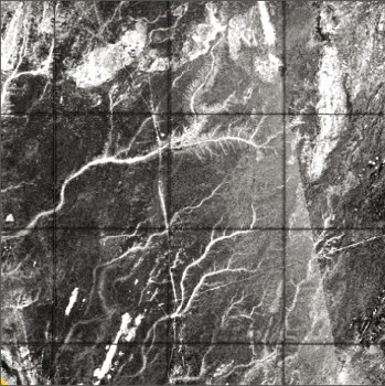
PALSAR image showing the ancient paleodrainage network (in bright, about 100km long on
the image) that connects the Tamanrasett River valley to the Cap Timiris Canyon
Marine sediment records off Western Sahara indicate deposition of river-borne material at those times, implying sustained fluvial discharges along the West African margin.
Using images from orbital radar PALSAR, we discovered a large paleodrainage network on the Mauritanian coast, connecting the submarine Cap Timiris Canyon to the Tamanrasett River valley, previously proposed as a possible vast ancient hydrographic system that would have flown from the Hoggar highlands and southern Atlas to the Atlantic.
Ch. Skonieczny, Ph. Paillou , A. Bory, G. Bayon, L. Biscara, X. Crosta, F. Eynaud, B. Malaizé, M. Revel, N. Aleman, J.-P. Barusseau, J. Vernet, S. Lopez, F. Grousset, "African Humid periods triggered the reactivation of a large river system in Western Sahara", Nature Comm., Nov. 10th, 2015, doi: 10.1038/NCOMMS9751.