Lake Ulaan Nuur
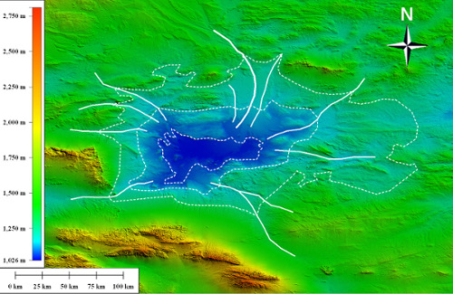
Three main lake levels (dotted lines) ontop of SRTM topography, Ongi River
and potential palaeochannels discovered using PALSAR images (solid lines)
at the Ulaan Nuur depression.
Shallow water is an essential resource for rural communities and has become significant source for urban centres, agriculture and mining.
In the past conventional methodologies were used in the search for water; today advanced remote sensing from space offer new techniques to identify and define potential untapped groundwater in drylands. This research investigates a potential major water resource in the Gobi Desert, Mongolia. Using remote sensing from space we integrated topography, radar images and optical images into GIS tools to investigate and identify potential shallow water correlated to large palaeolakes. This work integrates the palaeoclimatic history of southern Mongolia with present water circumstances in the region.
Findings indicated Lake Ulaan Nuur as a promising site for hydro-geological testing and water resource prospecting as measurement suggests a past lake area of >19,000 km2 in the Mongolian Gobi.
T. Sternberg, Ph. Paillou, "Mapping potential shallow groundwater in the Gobi using remote sensing: Lake Ulaan Nuur", Journal of Arid Environments, vol. 118, pp. 21-27, 2015.